area homepage The East Lavington Guide
[Woollavington]
West Sussex, England
main index click for
Rother Valley
homepage
The Rother Valley
West Sussex, England

East Lavington
index

Vintage Trail | Old English Taverns & Pubs | headstones | photo galleries | local travel | emergency services archive | churches | old local railways | contact | more

Petworth Cottage Museum The Vintage Trail
Wander the area and Sussex using hundreds of old photos and postcards The Rother Valley Trail
Tour the Valley using using hundreds of photos police Whats that Police Helicopter doing over my house
Police helicopter
over my house
Pubs
 

East Lavington
Woolavington
WEST SUSSEX

East Lavington House and church
photo: CDrakew 2008
East Lavington House and Church 2008
 
East Lavington & Upper Norwood
Ordnance Survey grid ref : SU946162
Petworth 4 miles, London 45 miles
Nearest post town, Petworth
Postcode GU28 - Dial code 01798
 
Clerk of East Lavington Parish Council
contact details & information
complete list of local parish clerks
 
 
889 baptisms on OPC Database from 1571 - 1874.
312 marriages on OPC Database from 1571 - 1875.

listed under Woolavington
 

Olympic Torch Relay route

16 July 2012
 
 
Nearest passing point
for East Lavington

The Torch was carried through Duncton
click for video
& 'turn out'numbers


click for
The EAST LAVINGTON
Parish Council Website

For local information, Parish Council news
events & general local chat.


INDEX
East Lavington maps
East Lavington photographs
East Lavington Parish Council
 
Walk from Graffham through
East Lavington

 
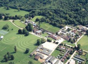
Aerial photograph
Church - St Peter
Duncton
Fire Service
Ellena Whittington
Graffham
John Sargent
PO Directories 1851 & 1867
Seaford College
Willow Cottage
 

Not found it? - try main index
or search whole site below
search Gravelroots    
Index of all the words on Gravelroots


William Hopkins Bankruptcy 1884
Farmer & Lime Merchant
London Gazette, 12 Sept.1884
Barnetts Farm, East Lavington


East Lavington is a small village and parish nestling below the South Downs in West Sussex. To the west of the A285, Petworth to Chichester road, between its neighbours Duncton and Graffham.
The parish has a land area of 1968 acres. East Lavington parish includes the hamlet of Upper Norwood. East Lavington showed 357 people in the 2001 census living in 87 homes.
The old East Lavington parish church has now become the chapel for Seaford College, a large private school which was established here in 1946 after its original site, at Seaford, was taken over in WW2 by the military.


East Lavington from the air
photo: Boston500
East Lavington from the air


Woolavington - { East & West Woollavington }
The modern civil parish of East Lavington now occupies much of the former ancient { East } Woolavington parish. What is now East Lavington and now West Lavington near Midhurst were originally one parish. Below is part of Kellys 1867 Post Office Directory for Woollavington, part of which reads.....
 
The parish consists of several portions, lying at a considerable distance apart, but of these two only are specially distinguished, by the prefix East and West; that which is known as East Woolavington is the older portion of the parish, and that which is described above - the other part - West Woolavington, joins Midhurst and forms for a considerable distance the eastern boundary of the high road from Midhurst to Chichester, so that now it is usual to describe the divisions thus - East Woolavington, near Petworth, and West Woolavington, near Midhurst.
Read here for more information..


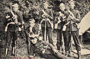
Seaford Cadets c.1911
Seaford Cadets c.1911 - click


CHINGFORD POND IMPROVEMENTS
Public Exhibition To Be Held
 
Oct.2012 - click for information
 

Not found it?
try main index
or search whole site
use one or two keywords
search index of every word on Gravelroots
 
Last post

Stone pillow - Help for the local homeless - free advert sponsored by Gravelroots
 
dogs trust - free advert sponsored by Gravelroots
 
RNLI - free advert sponsored by Gravelroots


The Vintage Trail is part of Gravelroots based at Fernhurst on the Sussex, Surrey & Hampshire border.
Information and images are updated throughout this site on a constant daily basis. If you regularly use or
have visited these pages previously remember to refresh the pages for any new entries...Refresh page.
Please let us know if you are searching for specific information and unable to find it, or you see errors.
 
Your advert on this page.
 
IMAGES

Many images shown are often available to print etc. via higher resolution downloads. - details here.
Our offline archives are very extensive. Seeking a specific image? eMail us


Todays photos, observations and news are tomorrows history, be part of it.
You can add photos, documents or information to these pages, or start a new one.
Simply e-mail your material to us & share it with everyone. Your material can be credited to you.
 
A short selection of links to some of the many other sections from Gravelroots
Vintage Trail - - Old Pubs of England - - emergency services archive - - Rother Valley Trail - - Headstones - - Churches - - more
 
This page is part of Gravelroots
Searching for something specific, use the indexes
This site is best viewed full screen, F11, in 1024 x 768 or higher
WaterAids vision is of a world where everyone has access to safe water and sanitation
Advert sponsored by Gravelroots.net

 
Why do we show adverts, how is the site funded? - Support us
Gravelroots
copyright information
page top
 
main index
 
Growing old is mandatory, growing up is optional.


    last page edit Nov.2023
    prv page edit Jan.2019
    .1st page edit Mar.2009

 
    Curator-Editor- Phil Dixon, Fernhurst

Valid CSS
page protected by copy sentry